


You can define local coordinate systems (LCS) for use in geometry, mesh, blocking or boundary condition manipulation using the LCS icon in the main menu. The default coordinate system located at the origin is called Global.
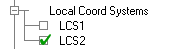
When a LCS is defined, its name will appear in the display tree as shown below. Deactivating all Local Coordinate Systems in the Display tree will activate the Global coordinate system. You can view only one LCS at a time.
Right-click a defined coordinate system in the Display Tree for the following options.
- Delete
Removes the LCS from the display tree and its data from the geometry and parameter files.
- Modify
Opens the Define Local Coordinate System DEZ to allow you to modify the coordinate system.
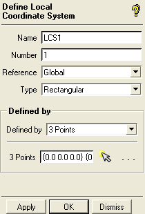
See Local Coordinate Systems in the Main Menu chapter for the description of all the options.
- Rename
Opens a dialog box where you may give the LCS a new name.
- Flip Axis
Cycles the LCS axes through the sequence X-Y-Z, to Z-X-Y, to Y-Z-X, back to X-Y-Z relative to the original LCS. For non-rectangular coordinate systems the transformation is the same, except using the R, θ, and Z axes, or the R, θ, and Φ axes.
This approach is useful to transform a Z-dominant coordinate system to an X-dominant or Y-dominant coordinate system. For example, if you want to change the orientation for the 1-point definition method or have the first two points of the 3-point method define something other than Z-direction, it might be best to define the LCS in the easiest method possible and Flip Axis to get the appropriate LCS.