


Roadway Lighting
This feature is only available in the Premium and Enterprise editions of Ansys Zemax OpticStudio.
Calculates CIE 140-2000 roadway lighting data.
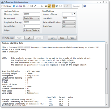
Mounting Height The distance in lens units from the roadway to the lamp origin.
Arrangement The arrangement of lamps. Choose single side, double side, or staggered.
Longitudinal Spacing The spacing between lamps in lens units along the direction of the roadway. For single and double side arrangements, this is the spacing between two adjacent lamps on the same side of the road. For staggered arrangement, this is the spacing along the road of adjacent lamps on opposite sides of the road. The spacing of adjacent lamps on the same side of the roadway would, therefore, be two times the spacing.
Lateral Offset The lateral lamp offset in lens units. This is the transverse lamp position, relative to the edge of the roadway. This value can be positive or negative.
Origin The object that represents the origin of the lamp coordinate system.
Number of Lanes The number of lanes on the roadway.
Lane Width The width of each lane in the roadway in lens units.
Surface Classification The road surface classification. This corresponds to the specularity of the road surface. Currently R1, R2, R3, and R4 are supported.
Road Class The roadway class. This determines the specifications required to have a passing roadway. Currently ME1, ME2, ME3A, ME3B, ME3C, ME3D, ME4A, ME4B, ME5, ME6, CE0, CE1, CE2, CE3, CE4, and CE5 are supported.
Discussion
This analysis computes roadway lighting data according to CIE 140-2000 "Road Lighting Calculations". A quick indication as to whether the lamp passes the specifications dictated by the defined road class is provided along with the calculated value. While all settings are defined in system units, the computed data is always returned in units of meters and lumens, per the specification.
There are two methods intended for the usage of this analysis. This first is to simply analyze an existing lamp whose far-field intensity is defined in a *.IES or *.LDT file. In this case the far-field data file should be specified as the origin object in the settings and OpticStudio will only account for that source in the computation. The second is for the user to define sources and geometries associated with the roadway lamp in the system; no other objects or detectors should exist in the system. OpticStudio will trace analysis rays from all defined sources and compute the data based upon the far-field intensity pattern. In both scenarios the calculation is done assuming the origin object's local x-axis is the longitudinal direction (along the roadway), and the local y-axis is the transverse direction (across the roadway). Note that some IES/LDT files have data defined assuming different lamp orientations. Make sure to confirm this and rotate the source, if necessary, before using this analysis.
An associated capability is the ability to optimize lamps to pass these specifications. See "NSC Roadway Merit Function Tool" for details.
Next: